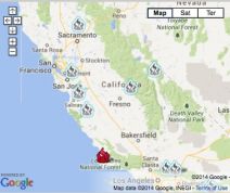
Bernardo fire map: San Diego fire burns through 800 acres, only 5 percent contained
The Bernardo wildfire, which broke out early Tuesday morning has forced the evacuation of over 20,000 homes in the San Diego area. So far, only five percent of the fire is contained.
The fire, which broke out near Camino San Bernado west of Del Norte High School, started at 10. 40 a.m. local time. Dry weather and windy conditions forced the fire to spread fast, burning over 800 acres of land.
Two high schools and an elementary school have been evacuated earlier.
Residents living in the northern San Diego county, including Black Mountain, Fairbanks Rand, and eastern Rancho Santa Fe areas were all ordered to evacuate.
Residents can go to evacuation centers that have been set up in Torrey Pines High School, Poway High School and Rancho Bernardo High School.
See the interactive map of the Bernardo fire below.